
The Institute of Information Systems is subordinate to the first-level discipline of information and communication engineering (national key first-level discipline), including two second-level disciplines, namely, communication and information systems (national key second-level discipline) and information networks and complex systems. The Institute has developed three distinctive and advantageous research directions, namely, navigation and positioning, detection and sensing, and network collaboration, which have significant influence in the domestic and international academic and industrial communities.
The Institute has 21 faculty members, more than 150 doctoral and master's degree students, and more than 20 postdoctoral fellows. The Institute enrolls more than 20 doctoral and master's degree students every year, undertakes the teaching of more than 20 undergraduate and postgraduate courses, and presides over and participates in the compilation of a number of textbooks such as Introduction to Machine Learning, Digital Signal Analysis and Processing, and Stochastic Processes and Their Applications. In recent years, it has cultivated a wide range of socialist-minded and professionally competent talents including 2 national outstanding doctoral thesis winners, 1 national outstanding postdoctoral fellow, and 1 national excellent instructor.
In recent years, the Institute has undertaken and completed a large number of scientific research and technological research projects from the state, ministries and enterprises, and has made a number of major breakthroughs in the technical system and core technologies, published a number of high-quality academic papers, and won dozens of national, provincial and ministerial awards including the first prize of national invention.
The main research directions are as follows:
I. Navigation and Positioning
nGlobal Navigation Satellite System (GNSS) and Its Applications
Focusing on the design, generation, transmission, reception and application of GNSS signals, carry out research on signal processing and system simulation of satellite navigation, with emphasis on the design of a new generation of satellite navigation signal structures, development of key technologies and prototypes of general-purpose GNSS receivers as well as special receivers, development of GNSS software receivers and study of GNSS/INS combined navigation technologies.
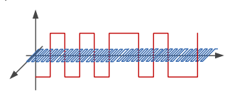
Design of signal structure for new generation BeiDou system
nSatellite-independent Positioning and Navigation Technologies
Mainly researching self-organized and networked new spatial and temporal information systems that can be deployed on demand and randomly, regional positioning systems that can autonomously establish and dynamically maintain spatial and temporal references, as well as multi-source fusion indoor positioning, Bluetooth positioning, and UWB signal positioning technologies.
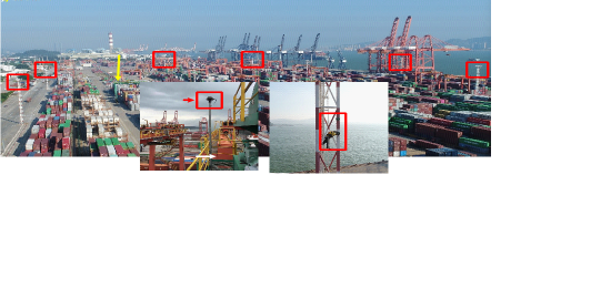
Regional positioning systems for precise positioning of port equipment
nSatellite Navigation Security and Countermeasures Technologies
Mainly working on the general techniques of satellite navigation countermeasures and related key technologies, including reconnaissance and analysis of navigation signals, simulation and performance evaluation of navigation signals, and so on.

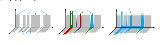
New navigation and positioning technology test platform
II. Detection and Sensing
nFrequency Agile Coherent Radar
Mainly studying the waveform design, coherent Doppler processing, target detection, clutter suppression and other technologies of Frequency Agile Coherent Radar in complex electromagnetic environment.
nRadar polarization theories and radar imaging technologies
Studying optimal polarization theory, clutter modeling and clutter suppression, target feature parameter extraction, target detection and classification, polarization SAR and polarization interferometric SAR system parameter design demonstration, multi-band polarization SAR data fusion, SAR image-based flight platform localization, SAR/ISAR imaging technologies, sparse inversion-based radar imaging technologies, synthetic broadband radar signal processing, and so on.
nMulti-source Heterogeneous Remote Sensing Data Fusion Technologies
Studying the association and collaborative feature mining technology of multi-source heterogeneous remote sensing data, the technology of change detection and target identification based on the fusion of multi-source heterogeneous remote sensing data, the technology of situational inversion and prediction, and so on.
nMultifunctional Integration Technologies
Exploring and researching the basic theories and implementation methods of multifunctional integration of electromagnetic space such as detection, jamming, reconnaissance, communication and navigation.
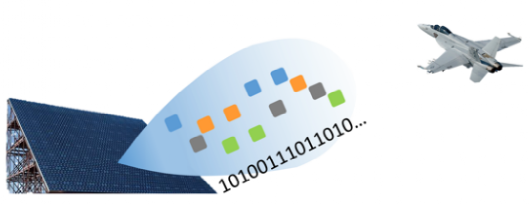
Frequency agile coherent radar and multifunctional integration technology
nSoftware Defined Radar
Mainly studying radar hardware and software decoupling open architecture, modeling/visualization software integration framework, cross-platform automatic code generation, resource virtualization management monitoring, automatic task deployment mapping and other technologies.
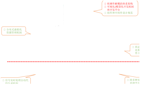
Software defined radar technology
III. Network and Collaboration
nCooperative Localization and Perception Technologies
Mainly studying cooperative localization and navigation, cooperative target detection, distributed cooperative scheduling, cooperative network formation, large-scale array signal dimensionality reduction, network relative localization, localization network resource allocation, cooperative visual three-dimensional reconstruction and other technologies.
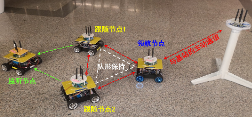
Coordinated localization and formation systems
nCooperative Intelligence Technology
Mainly studying the complex environment-oriented agent self-organization network and network resource scheduling method, the cluster cooperative positioning methods under the condition of communication limitation, and the complex environment multi-machine cooperative decision-making mechanism based on reinforcement learning.
nSea-Sky Integrated Information Network
Mainly studying the theories of multi-dimensional and multi-scale marine network collaborative organization, the basic theories of sea-sky integration network resource optimization, the key technologies of communication and monitoring and their applications in the marine industry.
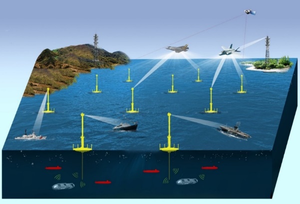
New marine information networks
nIntelligent Bionic Unmanned Underwater Vehicle
Mainly studying the design and prototype development of bionic unmanned underwater vehicles, multi-UV path planning, formation control, trajectory tracking and other methods for complex sea conditions.
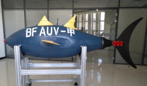
Intelligent bionic unmanned underwater vehicle
nCryo-electron Microscopy Microscopic Image Processing
Mainly studying single-particle 3D reconstruction, microscopic image recognition, CTF correction, etc.
Institute of Information System
![]()